Scenic Drives

Badlands Loop State Scenic Byway
It would take about one hour to drive the 39-mile loop of South Dakota Highway 240 between the towns of Cactus Flat and Wall without stopping, but almost no one does that. Breathtaking rock formations and native grasslands filled with numerous species of plants and animals guarantee you’ll want to pause somewhere along the route to enjoy the view. There are 16 designated scenic overlooks that make for outstanding photo opportunities.
Peter Norbeck National Scenic Byway
Some of the most incredible roads anywhere make up the Peter Norbeck National Scenic Byway in the Black Hills of western South Dakota. Mix in America’s most patriotic monument along the way and you have a never-to-be-forgotten road trip. Peter Norbeck was a visionary Senator and Governor for South Dakota. He personally chose the layout of the Iron Mountain Road in the 1930s and persisted in building it, even after being told it couldn’t be done. A masterpiece of artistic engineering, this 70-mile byway includes spiraling bridges, hairpin curves, granite tunnels and awe-inspiring views. No wonder it was named one of the 10 Most Outstanding Byways in America. Roughly a figure-eight route, the byway travels through portions of Custer State Park, the Norbeck Wildlife Preserve, near Mount Rushmore National Memorial and the Black Elk National Wilderness Area. Highways 16A, 244, 89 and 87 combine to create the route. A good starting point is the town of Keystone, near the foot of Mount Rushmore. Winding southeasterly up Highway 16A, also known as Iron Mountain Road, the route leads you around impressive wooden “pigtail” bridges. Several tunnels carved through the granite mountain not only provide a transportation passage, but artistically frame the four faces on Mount Rushmore in the distance. Continuing west into Custer State Park, Highway 16 intersects with Highway 87, also known as the Needles Highway. Here the road climbs around fantastic granite pinnacles that are a favorite with rock climbers from across the globe. Twisting and turning between the Needles and through a tight tunnel/crack in the rock, this portion of the byway leads to picturesque Sylvan Lake. From here, drivers can choose to turn south and then east to visit more of Custer State Park, or continue north and east back to Mount Rushmore. Beautiful mountain lakes and rocky terrain greet you around every turn. Shaggy white mountain goats, deer and chipmunks are among the commonly-seen wildlife along the way. You will want to devote most of a day’s time to the Peter Norbeck National Scenic Byway. Count on many stops for photographs along the way and a visit to Mount Rushmore National Memorial.
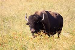
Wildlife Loop Scenic Byway
Searching for animals you don’t see in your neighborhood? Custer State Park’s 18-mile Wildlife Loop State Scenic Byway has what you are looking for! Winding through pine-covered hills, rolling prairies and red-walled canyons, the Wildlife Loop is one of the highlights of a park that has many. Make it a morning or evening drive for your best chances at catching the animals in action. Buffalo are the big stars here and you should find at least a portion of the 1,300-head herd along the byway. They are seemingly gentle, but deceptively fast and dangerous, so stay in your vehicle when around them. Bighorn sheep, pronghorn, deer, elk, coyote, prairie dog and numerous bird species including wild turkey can all be seen at times along the Wildlife Loop. Quite often found near the loop road’s southeastern tip, wild burros that don’t seem so “wild” will beg for snacks from passing vehicles. Descendants of a herd that once provided trail rides in the park, these docile donkeys don’t need junk food any more than we do. Park rules prohibit feeding any animal in the park, so no matter how much they beg, refrain from actually sharing your lunch with the burros. For those inclined to get out of the car, two hiking trails are located along the Wildlife Loop. The Prairie Trail is a moderate three-mile loop into the grasslands where numerous wildflowers bloom throughout the spring and summer. The Centennial Trail intersects the byway near its western end. Approximately 22 miles of the Centennial Trail is located inside Custer State Park, giving hikers a chance to really exercise if they choose. If you would like to have a knowledgeable guide along on your Wildlife Loop excursion, check at Custer State Park headquarters for the caravan tour, which departs at 6 p.m. each summer evening. It will vary depending on how much time you spend enjoying the buffalo herd or making friends with burros but allow at least an hour to drive the Wildlife Loop State Scenic Byway.
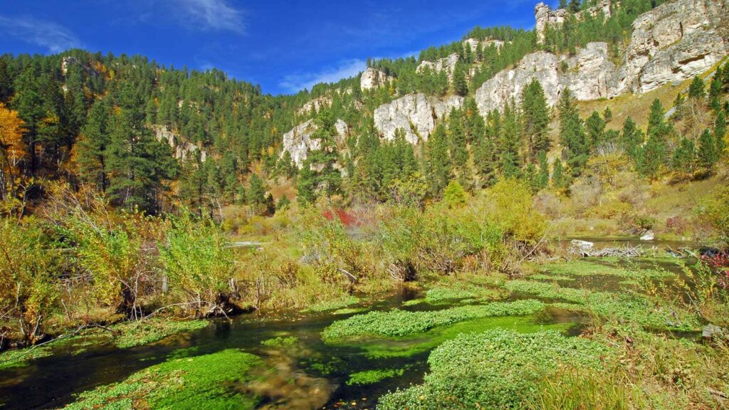
Spearfish Canyon State & National Forest Service Scenic Byway
Spearfish Canyon Scenic Byway throngs with summertime pleasure drivers. Thousand-foot-high limestone palisades in shades of brown, pink and gray tower to the right and left of Highway 14A as it twists through the 19-mile gorge. The 22-mile journey begins at Exit 10 or Exit 14 off Interstate 90 in Spearfish and connects to the mouth of the canyon at the Spearfish Canyon Country Club. From the other end, turn at Cheyenne Crossing outside of Lead at the intersection of Highway 85. From there, travel 20 miles through some of the most breathtaking scenery you’ll find. Spearfish Creek lines the canyon floor while canyon waterfalls make for popular roadside attractions. Bridal Veil Falls and Roughlock Falls are must-sees along the route. The speed limit is 35 miles per hour, but you’ll find so many drivers enthralled by the beauty, they drive even slower. Others simply pull over at one of the dozens of pull-offs along the way and get out to stretch their legs and capture the perfect Kodak moment. The red brick walls and large plate windows of the Maurice Hydro Power Plant about midway through the Canyon offer a reminder of the Homestake Gold Mine operation in Lead, just a few miles up the road. Other stops along the way are Spearfish Canyon Lodge and the Latchstring Restaurant. Visit Cheyenne Crossing Store at the other end of the Canyon and browse the gift shop or eat lunch in the award-winning café. Hikers enjoy exploring the side canyons like Iron Creek or Eleventh Hour Gulch, aptly named because it only gets one hour of sunlight a day; and bicyclists love the wide shoulders and uniform 3% grade of the road. Bicycling Magazine has named Spearfish Canyon one of the top 50 scenic bike paths in the country. Famous for its beauty, Spearfish Canyon was the location for several scenes in the movie epic, “Dances with Wolves.” The site is on Forest Road 222 about three miles upstream from Spearfish Canyon Resort. Spearfish Canyon is a beautiful drive any time of year but Fall offers the most colorful drive through the Canyon, as Mother Nature paints the leaves in shades of yellow, gold and red to accent the evergreen backdrop. The changing of the leaves normally peaks during the first week of October. As the elevation changes nearly 2,000 feet from one end of the Canyon to the other, the weather and the stage of changing leaves can vary. It is best to call ahead if you’re headed into the higher elevations during the Fall, winter or spring months. Experience the nature, history and adventure of the Black Hills with a drive on the beautiful Spearfish Canyon Scenic Byway.
Location: Spearfish South Dakota